- What are the best HD map apps for exploring the Olympic Peninsula offline?
For reliable offline navigation on the Olympic Peninsula, consider AllTrails for hiking maps, Gaia GPS for backcountry, or simply download Google Maps areas. These apps often feature detailed topographical data and points of interest crucial for navigating remote areas where cell service is limited.
- Where can I find detailed satellite images of Olympic National Park roads and trails?
Detailed satellite images of Olympic National Park roads and trails are readily available through Google Earth and Bing Maps, offering high-resolution aerial views. Park-specific resources like the National Park Service website also provide interactive maps with satellite overlays, helping you visualize terrain and plan routes.
- How do I use digital maps to find scenic viewpoints on the Olympic Peninsula?
To find scenic viewpoints, open your preferred navigation app like Google Maps or Apple Maps and search for "scenic viewpoints Olympic Peninsula" or specific landmarks like "Hurricane Ridge overlook". Look for photo icons or user-generated content on the map, often accompanied by reviews and stunning images.
- Are there interactive maps showing real-time road conditions for the Olympic Peninsula?
Yes, for real-time road conditions on the Olympic Peninsula, check the Washington State Department of Transportation (WSDOT) website, especially their "Pass Reports" and "Travel Alerts" sections. Additionally, local park websites like Olympic National Park provide crucial updates on closures and weather impacts via interactive maps.
- What are the top 3 must-see spots on the Olympic Peninsula according to HD map reviews?
Based on high ratings and map reviews, the top three must-see spots are Hurricane Ridge for panoramic mountain vistas, the Hoh Rain Forest for its lush, unique ecosystem, and Rialto Beach or Ruby Beach for iconic coastal views and sea stacks. These locations consistently receive stellar reviews for their stunning visuals.
- Can I pre-plan a multi-day itinerary using an interactive map of the Olympic Peninsula?
Absolutely, you can pre-plan a multi-day itinerary using interactive maps. Tools like Roadtrippers, Google My Maps, or even custom routes within Apple Maps allow you to pin multiple stops, estimate travel times, and visualize your entire journey across the Olympic Peninsula. This is great for optimizing your trip.
- What is the best way to get a physical, high-quality map of the Olympic Peninsula?
The best way to get a physical, high-quality map of the Olympic Peninsula is to purchase a National Geographic Trails Illustrated Map or a detailed Green Trails Map. These are available at outdoor retailers like REI, local visitor centers, and many park entrance stations. They are durable and excellent for backcountry use.
Embark on an unforgettable journey across Washingtons stunning Olympic Peninsula in 2026. This comprehensive guide, tailored for Gen Z and millennial explorers, empowers you to navigate dense forests rugged coastlines and majestic mountains with ease. Discover how cutting-edge digital maps and local insights are essential tools for finding hidden waterfalls pristine beaches and towering old-growth forests. From real-time trail conditions to locating the best coffee shops and camping spots this resource ensures you maximize every moment. Leveraging your mobile device you will access invaluable data on road closures weather patterns and points of interest making your adventure seamless and highly personalized. Prepare to explore the Map Of The Olympic Peninsula like a local optimizing your experience for breathtaking sights and unforgettable memories.
- Where are the best spots for scenic photography on the Olympic Peninsula? - For stunning shots, head to Hurricane Ridge at sunrise or sunset for mountain views. The moss-draped trees of the Hoh Rain Forest offer unique compositions, and Rialto Beach or Ruby Beach provide dramatic coastal landscapes with sea stacks and driftwood.
- How do I find pet-friendly trails using a Local MAP on the Olympic Peninsula? - Many mapping apps like AllTrails allow filtering for pet-friendly trails. Remember, most trails within Olympic National Park have leash rules or prohibit pets due to wildlife. Always check specific park or forest service regulations for the most accurate info.
- What are the current road conditions to Hurricane Ridge according to Maps? - To check current road conditions to Hurricane Ridge, pull up your preferred mobile Maps app. Also, cross-reference with the Olympic National Park website or WSDOT for real-time updates, as winter closures due to snow are frequent, and summer capacity limits can occur.
- Are there free camping locations shown on maps of the Olympic Peninsula? - Free camping, often called dispersed camping, can be found on maps within Olympic National Forest lands (not the National Park). Use apps like iOverlander or The Dyrt which often highlight free spots. Always adhere to Leave No Trace principles and local regulations.
- What are popular kayak or paddleboard launch points on Olympic Peninsula maps? - Popular launch points include Lake Crescent (near the Lodge or Fairholme Campground) and various spots along Hood Canal. For ocean kayaking, experienced paddlers often launch from calmer bays. Always check wind and tide conditions before heading out.
- How can I find the nearest gas stations and EV charging points on the Olympic Peninsula via map? - Your mobile Maps app is the easiest way. Simply search "gas stations near me" or "EV charging Olympic Peninsula." Keep in mind that options can be sparse in remote areas, so plan fuel stops carefully, especially for electric vehicles.
- What unique wildlife viewing locations are highlighted on Olympic Peninsula maps? - Maps can highlight wildlife hotspots. Hurricane Ridge is excellent for deer and marmots. The Hoh Rain Forest may reveal elk. Coastal areas like Rialto Beach or Neah Bay are great for spotting marine life such as sea otters and eagles. Always observe from a respectful distance.
Ready to explore the breathtaking Olympic Peninsula? This guide cuts the fluff, getting straight to how you can best navigate its vast landscapes using modern map tools. Whether you are chasing rainforest giants, rugged coastlines, or majestic mountain views, having the right map of the Olympic Peninsula is crucial for an epic adventure.
Frequently Asked Questions
Where are the absolute best locations to visit on the Olympic Peninsula?
The absolute best locations include Hurricane Ridge for mountain views, Rialto Beach for coastal beauty, and the Hoh Rain Forest for its unique ecosystem. Also check out Lake Crescent and Sol Duc Falls.
How can I best utilize Local MAP or Maps for navigating the Olympic Peninsula?
Pull up your preferred mobile Maps app to verify real-time hours, as peak weekend times fill up fast. Download offline maps for areas with no cell service, especially deep within Olympic National Park. Always cross-reference with park ranger updates for trail conditions and road closures.
What are the best times to visit the Olympic Peninsula for fewer crowds or specific activities?
Visit during the shoulder seasons (late spring or early fall) for fewer crowds. Summer offers best weather but expect high visitor numbers. Winter is ideal for storm watching on the coast, but be prepared for wet conditions and potential road closures, especially at higher elevations.
- Hurricane Ridge - Olympic National Park - Scenic Mountain Overlook
- Rialto Beach - La Push - Pacific Coastline, Sea Stacks
- Hoh Rain Forest - Olympic National Park - Temperate Rainforest Trailhead
- Lake Crescent - Olympic National Park - Freshwater Lake, Lodge
- Ruby Beach - Kalaloch - Rugged Coastline, Driftwood
- Port Angeles - Northern Olympic Peninsula - Gateway to Park, Ferry Terminal
- Forks - Western Olympic Peninsula - Twilight Town, Logging History
All maps discussed here focus on helping you explore every corner of the incredible Map Of The Olympic Peninsula effectively and efficiently.
Explore iconic Olympic Peninsula locations effortlessly with modern map navigation. Discover hidden gems, find the best trails, and plan your adventure using up-to-date digital mapping tools for a seamless journey through stunning landscapes from rainforest to coastline.


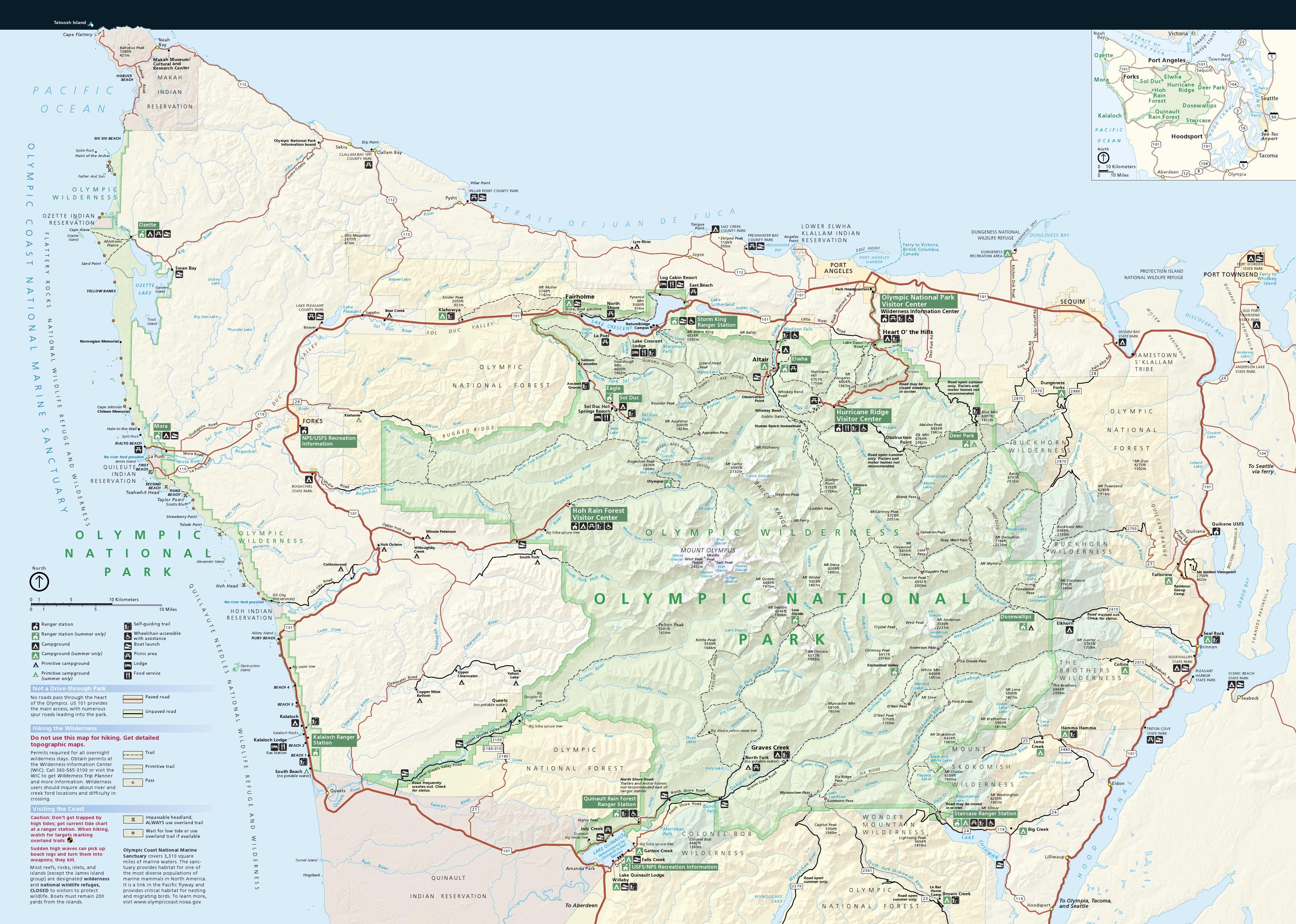
Map Of Olympic Peninsula Washington State USA Map Of Olympic Peninsula . Peninsula Olympic 2025 Olympic Penninsula Map . Peninsula Olympic 12585409 F520 1 . Olympic Peninsula Trail Map Olympic National Park And Peninsula Map . Olympic Maps NPMaps Com Just Free Maps Period Olympic Map



Olympic Mountains Olympic Road Map . Olympic Peninsula Wall Map With Terrain Shading Metsker Maps KRO . Olympic National Park Peninsula Nature Birding Tour In Washington 1413 Olympic Peninsula Spring Explorer . Olympic Mountains Map . Map Of The Olympic Peninsula Area


Olympic Peninsula RV Trip Tracks Trails Map Rv Rental Olympic Peninsula . Peninsula Victoria Stock Vector Images Alamy Map Surrounding Olympic Peninsula And Greater Seattle Washington United States 2PTJ9TK . The Olympic Peninsula Map Area Maps LVWHK OlyPenMap . Jefferson County Washington Map Olympic Peninsula Olympic Peninsula Travel Guide Map . DARPAN Magazine Is The Premium Canadian South Asian Magazine Located In Olympic Map


Jefferson County Washington Map Olympic Peninsula Olympic Peninsula Guide To Olympic National Park And Olympic In Washington State National Parks Map . Olympic Peninsula Washington Map WA Olympic May07 . Map Of Olympic Peninsula Olympic Park Map WDSS Locator Website6 . Interactive Map Of The Peninsula Olympic National Park Olympic Olympic Peninsula Interactive Map . Olympic National Forest Tribal Relations Forest Service Olympic National Forest Overview Map Park %2B Forest Lands %2B Wilderness %2B Tribal Lands


Olympic Peninsula Framed Prints Paper Cairns Olympic Peninsula Frame . The Best Uncrowded Beaches On The Olympic Peninsula WA OPVB 2021 Beach Map V3 1398x1080 . Peninsula Olympic Olympic Np Map . Peninsula Olympic Peninsula Map Travel 0410 . Peninsula Olympic Location Of And Land Ownership On The Olympic Peninsula


Peninsula Olympic Olympic Peninsula Road Trip Map 1500x937 . Peninsula Olympic Screen Shot 2020 05 25 At 8.39.04 PM . Olympic Peninsula Rivers Hydrology Map Metsker Maps PMG Olympic Peninsula Hydro . Olympic National Park Nature Birding Tour In Washington State 2026 1459 Olympic Peninsula Fall Explorer . Peninsula Olympic Washington NeahBay
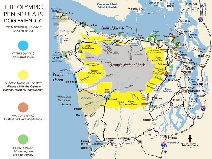


:max_bytes(150000):strip_icc()/olympicpeninsula-56a3fa085f9b58b7d0d4c5d8.gif)

RV The Olympic Peninsula Armadillo Tails Peninsula Map . Olympic Peninsula Vicinity 1953 Historic USGS 1 250 000 Il 26yf . Map Of Olympic Peninsula In Washington State Card12679 Fr . Olympic Peninsula Trip Planner . Olympic National Park Curtis Wright Maps All For One Map 04 26 21 300dpi 28.03x18.70 Inv2374c Scaled