Hunting maps are powerful tools for American hunters, providing crucial navigational and informational support in the field. These maps, whether digital or physical, detail public and private land boundaries, topography, vegetation types, and access points. They are vital for planning hunts, ensuring compliance with local regulations, and enhancing safety in diverse terrains across the United States. Modern hunting map applications offer advanced features like GPS tracking, weather overlays, and real-time landowner information, making them indispensable for both seasoned and novice hunters. Understanding how to effectively use a hunting map can significantly improve your hunting success rates and overall outdoor experience. Stay informed and prepared with the right map.
What is the primary purpose of a hunting map?
The primary purpose of a hunting map is to provide detailed topographical and boundary information for hunters. It helps users identify public and private land, plan routes, and understand terrain. This ensures safe and legal hunting practices.
How do I identify legal hunting areas using a hunting map?
Hunting maps typically use color-coding or distinct overlays to show legal hunting areas, like public lands or designated hunting zones. They mark private property lines clearly to prevent trespassing. Always cross-reference with local regulations and land ownership data.
Are digital hunting maps better than physical maps?
Digital hunting maps often offer real-time GPS tracking, satellite imagery, and weather updates, giving them an edge. Physical maps, however, never run out of battery and are reliable in all conditions. Many experienced hunters use a combination of both for optimal preparedness.
Can I find hunting regulations on a hunting map?
Some advanced hunting maps and applications integrate specific hunting regulations, season dates, and game management unit boundaries directly. While helpful, it is always crucial to consult official state wildlife agency websites. This ensures you have the most current and accurate regulatory information.
How do I use a hunting map for navigation in unfamiliar terrain?
To navigate unfamiliar terrain with a hunting map, use GPS tracking on digital maps to pinpoint your location. For physical maps, orient yourself using a compass and prominent landmarks. Follow trails, note elevation changes, and mark your path. This ensures you can always find your way back safely.
What features should I look for in a good hunting map?
A good hunting map should include clear land ownership boundaries, detailed topographical contours, and marked access points. Look for features like satellite imagery, GPS integration, and offline capabilities if digital. The map should be current and relevant to your specific hunting area.
Hunting map resources are indispensable for any hunter navigating the vast American wilderness. These specialized maps empower you to explore confidently and safely. They provide critical details you need before and during your hunting trips. Mastering the use of a hunting map transforms your outdoor experience. It ensures you are always aware of your surroundings.
Understanding hunting map features is key for successful excursions. A hunting map helps identify public land access and private property lines. This knowledge is crucial for legal and ethical hunting practices. It prevents accidental trespassing, keeping your hunt enjoyable. Many digital options offer satellite imagery and real time updates. These modern tools make planning and execution much smoother.
Using a hunting map effectively means more than just finding your way. It involves understanding terrain features and vegetation. Topographical information on a hunting map reveals elevation changes. This helps you predict animal movements and plan your approach. Rivers, trails, and roads are also clearly marked. These details are vital for strategic positioning and safe navigation.
What Others Are Asking About Hunting Maps?
What is the best hunting map app for USA hunters?
Many US hunters favor apps like OnX Hunt and Basemap. These applications provide detailed land ownership, public land boundaries, and topographical data. They offer offline capabilities and GPS tracking. Features like custom waypoints and shared maps enhance planning. These apps are constantly updated with crucial information, making them highly reliable tools.
How do hunting maps show public and private land?
Hunting maps use distinct color codes or overlays to differentiate public from private land. Public lands are often green or blue, while private lands might be white or gray. Property lines are clearly marked with boundaries and parcel numbers. This visual distinction helps hunters avoid trespassing. Always verify boundaries before entering new areas for compliance.
Are hunting maps useful for beginners?
Absolutely, hunting maps are incredibly useful for beginners. They help new hunters learn about hunting zones, navigate unfamiliar territory, and understand regulations. Maps offer a foundational understanding of the landscape. They promote safety and ethical hunting practices from the start. A good map builds confidence and reduces common beginner mistakes.
What kind of information can I find on a hunting map?
A comprehensive hunting map displays a wealth of information. You'll find land ownership details, property boundaries, and topographical contours. It includes access roads, trails, water sources, and vegetation types. Game management unit boundaries and specific hunting regulations are also often present. These elements aid in planning and decision making.
How do hunting maps improve hunter safety?
Hunting maps significantly enhance hunter safety by providing critical navigational awareness. They help you avoid getting lost in unfamiliar terrain. Knowing your exact location and surroundings is vital, especially in remote areas. Maps also identify potential hazards like steep cliffs or deep water. Staying informed through your map is a key safety measure.
FAQ About Hunting Maps
What is a hunting map?
A hunting map is a specialized navigational tool. It shows public and private land boundaries, topography, and other vital information for hunters. It helps locate game, plan routes, and stay safe in the wilderness.
Who uses hunting maps?
Hunters of all experience levels use hunting maps. They are essential for anyone venturing into hunting grounds. Landowners, wildlife managers, and outdoor enthusiasts also find them highly valuable.
Why are hunting maps important?
Hunting maps are important for legal compliance and safety. They prevent trespassing and help hunters navigate challenging terrains. Maps optimize hunting strategies and increase success rates effectively.
How can I get a hunting map?
You can acquire hunting maps through various sources. Digital apps are popular for smartphones and GPS devices. Physical maps are available from outdoor retailers, government agencies, and online stores.
| Feature | Description | Benefit to Hunter |
|---|---|---|
| Land Boundaries | Clearly marks public vs. private property lines | Prevents trespassing, ensures legal hunting |
| Topography | Shows elevation changes, contours, and terrain features | Aids in strategic positioning, predicting animal movement |
| Access Points | Identifies roads, trails, and parking areas | Helps in planning entry and exit routes |
| Vegetation Types | Indicates forest, open fields, water sources | Informs about potential game habitat and cover |
| GPS Tracking | Real-time location display on digital maps | Ensures safety, helps retrace steps, prevents getting lost |
Hunting map technology has come a long way, offering incredible advantages. Embracing these tools means you are making a smart choice for your hunting adventures. Always double-check local regulations and stay informed. Enjoy your time in the great outdoors, equipped with the best information.
Hunting map provides crucial boundary information, topography details, and navigation tools. Digital hunting map apps offer real time data and GPS tracking. Essential for safety and compliance in the wilderness.
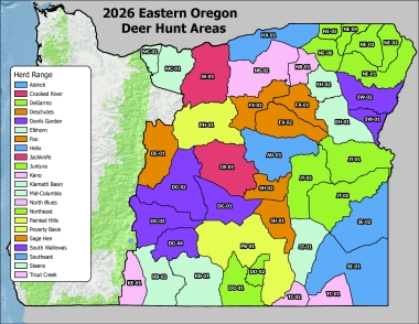 Eastern Oregon Deer Hunt Areas For Oregon Department Of Fish Updated Sept
  Texas Hunting Season Dates Texas Hunting Fishing Lone x .webp
 Oregon Mule Deer Plan Oregon Hunting Mule Deer Map Page
 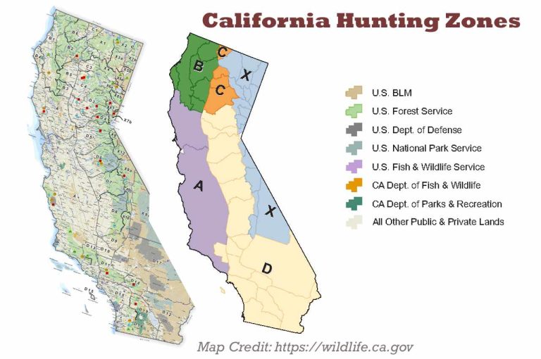 California Hunting Season New Dates Rules Limits Your California Hunting Zones x
 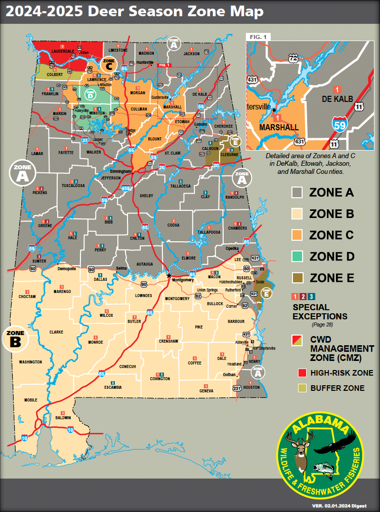 Deer Season Mississippi Ultimate Guide And Tips The Deer Alabama Deer Season Start Date
 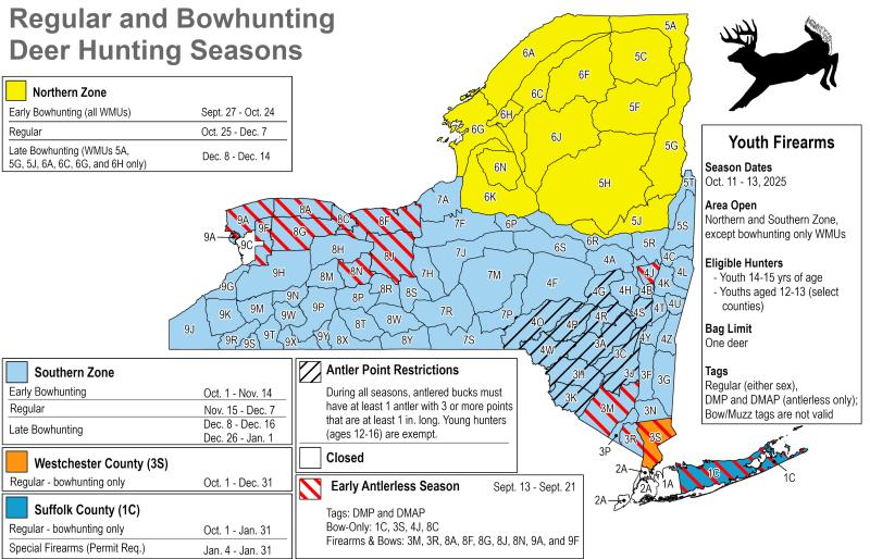 Hunting Season In The Northeast New York New Jersey Trail Conference NY Hunting Map
 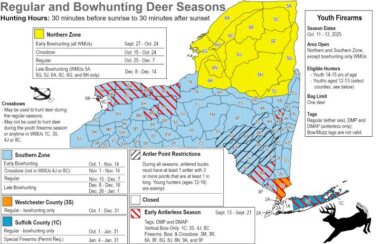 NYS Hunting Season Dates Regulations Licenses Deersznmap x
  Washington Hunting Seasons Tags Game Units Legal Weapons Hunter In Woodland Setting With Arkansas Wildlife Including Deer Turkey And Waterfowl Against Backdrop Of Natural State Terrain x
  Hunting And Trapping Regulations Synopsis Province Of British Columbia Synopsis Frontcover
  Colorado Unit Maps GMU MAP
  ATTENTION Draw Applicants NMDGF Screenshot At .. AM